
Karteikarten (10)
Karteikarte 1 von 10
OCR-Text
–
–
–
–
–
Extrahierte Daten
- Urheber:
- –
- Ort:
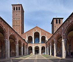
- Mailand, Sant'Ambrogio
- Titel:
- Sant'Ambrogio (Zerstörtes Nebengbäude)
- Material:
- –
- Kategorie:
- Architektur: Kirche
- Inv.-Nr.:
- 19300184; ZI007461
- Fotograf:
- Paoletti, Antonio (?); KS-I; Zentralinstitut für Kunstgeschichte, Photothek
Geomatch - Verknüpfung mit Normdaten (Orte) · 1
041_001
Gebäude Objekt / Institution
Adresse & Koordinaten · aus Wikidata
Piazza Sant'Ambrogio
20123 Mailand, Italien
45.46238, 9.17585 (street)
© OpenStreetMap-Mitwirkende Größere Karte
Bewertung 100 % · backfill
The candidate 'Sant’Ambrogio (Mailand)' explicitly describes the church in Milan, matching the building name and location perfectly, whereas other candidates refer to different cities, disambiguation pages, or unrelated buildings.
Datenquelle: Digitales Inventar (HiDA) · 1
007461
- Werktyp:
- Kirche
- Gattung:
- Architektur
- Datierung:
- 386-389 & nach 784 & 1098-1128
- Institution:
- Sant'Ambrogio
- Standorttyp:
- architecture
- Inhalt:
- Zerstörtes Nebengbäude
- Fotograf:
- Paoletti, Antonio (?)
- Aufnahmedatum:
- 1943
- Aufnahmeherkunft:
- KS-I
- Kommentar:
- schwere Zerstörungen; wiederhergestellt
- HIDA-ID:
- 190024
Maschinell aufbereitete Daten
- Kategorie:
- Architektur
- Zeitraum:
- 386-389 & nach 784 & 1098-1128
- Stadt (normiert):
- Mailand
- Land:
- Italien
- Institution (normiert):
- Sant'Ambrogio
- Einrichtungstyp:
- Bau / in situ
ZI-INVB-HIDW1-041_001