
Karteikarten (8)
Karteikarte 1 von 8
OCR-Text
1.H.16.Jh.
Le Lude (Sarthe)
Schloß:
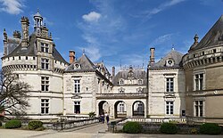
1. Fassade /125206
2. dto. /Ausschnitt /125207
3. dto. /Ausschnitt /125208
1. Fassade /125206
2. dto. /Ausschnitt /125207
3. dto. /Ausschnitt /125208
–
Arch. franz.
125206-125208
125206-125208
Extrahierte Daten
- Urheber:
- –
- Ort:
- Le Lude (Sarthe), Schloß
- Titel:
- Fassade; Ausschnitt
- Material:
- –
- Kategorie:
- Architektur / Frankreich
- Inv.-Nr.:
- 125206, 125207, 125208
- Fotograf:
- –
Geomatch - Verknüpfung mit Normdaten (Orte) · 1
326_01
Gebäude Objekt / Institution
Adresse & Koordinaten · aus Wikidata
Rue Jehan Daillon
72800 Le Lude, Frankreich
47.64755, 0.15890 (street)
© OpenStreetMap-Mitwirkende Größere Karte
Bewertung 100 % · production
The building name 'Schloß' combined with the address 'Le Lude' uniquely identifies the Château du Lude, which corresponds exactly to the Wikipedia article 'Schloss Le Lude' (index 5) located in the city of Le Lude.
Maschinell aufbereitete Daten
- Kategorie:
- Architektur
- Zeitraum:
- 1.H.16.Jh.
- Stadt (normiert):
- Le Lude
- Land:
- Frankreich
- Institution (normiert):
- Schloß
- Einrichtungstyp:
- Bau / in situ
Original: Le Lude (Sarthe)
ZI-INVB-PH47-326_01