
Karteikarten (8)
Karteikarte 1 von 8
OCR-Text
2.H.14.Jh.
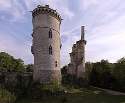
Mehun-sur-Yèvre (Cher)
Chateau
Chateau
Ansicht der Ruine von S.
Arch.französ.
127285
127285
–
Extrahierte Daten
- Urheber:
- –
- Ort:
- Mehun-sur-Yèvre (Cher), Chateau
- Titel:
- Ansicht der Ruine von S.
- Material:
- –
- Kategorie:
- Architektur / Frankreich
- Inv.-Nr.:
- 127285
- Fotograf:
- –
Geomatch - Verknüpfung mit Normdaten (Orte) · 1
489_01
Gebäude Objekt / Institution
Adresse & Koordinaten · aus Wikidata
Place du Général Leclerc
18500 Mehun-sur-Yèvre, Frankreich
47.14390, 2.21700 (street)
© OpenStreetMap-Mitwirkende Größere Karte
Bewertung 100 % · backfill
The building candidate 'Schloss Mehun-sur-Yèvre' exactly matches the building name 'Chateau' and the address 'Mehun-sur-Yèvre', describing the specific castle ruin located in that town.
Maschinell aufbereitete Daten
- Kategorie:
- Architektur
- Zeitraum:
- 2.H.14.Jh.
- Stadt (normiert):
- Mehun-sur-Yèvre
- Land:
- Frankreich
- Institution (normiert):
- Chateau
- Einrichtungstyp:
- Bau / in situ
Original: Mehun-sur-Yèvre (Cher)
ZI-INVB-PH47-489_01