
Karteikarten (8)
Karteikarte 1 von 8
OCR-Text
–
Cluny
Abteikirche
Abteikirche
Chorkap., Chapelle des Bourbons
u. westl. S-QS. v. NO
u. westl. S-QS. v. NO
161 810
Foto Marburg
35 683
35 683
Extrahierte Daten
- Urheber:
- –
- Ort:
- Cluny, Abteikirche
- Titel:
- Chorkap., Chapelle des Bourbons u. westl. S-QS. v. NO
- Material:
- –
- Kategorie:
- –
- Inv.-Nr.:
- 161810
- Fotograf:
- Marburg 35 683
Kurzinventar · 1
ZI-INVB-KPH-018 · Inv.-Nr. 161703 – 161917
- Herkunft:
- Foto Marburg
- Zugangsart:
- –
- Datum:
- 1973
Geomatch - Verknüpfung mit Normdaten (Orte) · 1
353_01
Gebäude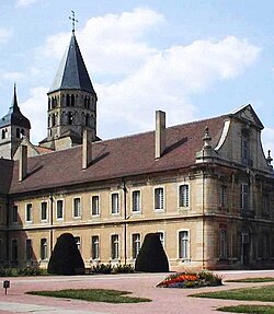
Adresse & Koordinaten · aus Wikidata
Rue du 11 Août 1944
71250 Cluny, Frankreich
46.43491, 4.65849 (street)
© OpenStreetMap-Mitwirkende Größere Karte
Bewertung 95 % · production
The building name 'Abteikirche' combined with the address 'Cluny' uniquely identifies the former abbey church of Cluny, which is the subject of the Wikipedia article 'Abtei Cluny'.
Maschinell aufbereitete Daten
- Kategorie:
- Architektur KI-Vorhersage
- Stadt (normiert):
- Cluny
- Land:
- Frankreich
- Institution (normiert):
- Abteikirche
- Einrichtungstyp:
- Bau / in situ
ZI-INVB-PH54-353_01