
Karteikarten (8)
Karteikarte 1 von 8
OCR-Text
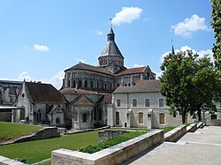
La-Charité-sur-Loire
Abteikirche
Abteikirche
–
Innen
S-QS, W-Wand, N-Joch
Mittelgeschoß, Kpt.-Zone re
S-QS, W-Wand, N-Joch
Mittelgeschoß, Kpt.-Zone re
166 583
Foto Marburg
33 951
33 951
Extrahierte Daten
- Urheber:
- –
- Ort:
- La-Charité-sur-Loire, Abteikirche
- Titel:
- Innen S-QS, W-Wand, N-Joch Mittelgeschoß, Kpt.-Zone re
- Material:
- –
- Kategorie:
- –
- Inv.-Nr.:
- 166583
- Fotograf:
- Marburg 33 951
Kurzinventar · 1
ZI-INVB-KPH-020 · Inv.-Nr. 166560 – 166874
- Herkunft:
- Foto Marburg 2fs 1312
- Zugangsart:
- –
- Datum:
- 1974
Geomatch - Verknüpfung mit Normdaten (Orte) · 1
388_01
Gebäude Objekt / Institution
Adresse & Koordinaten · aus Wikidata
Place Sainte-Croix
58400 La Charité-sur-Loire, Frankreich
47.17750, 3.01677 (street)
© OpenStreetMap-Mitwirkende Größere Karte
Bewertung 95 % · production
The building name 'Abteikirche' in La Charité-sur-Loire refers to the former Benedictine abbey church, which is the Notre-Dame de La Charité, and candidate [2] is the only article describing this specific church in the correct location.
Maschinell aufbereitete Daten
- Kategorie:
- Architektur KI-Vorhersage
- Stadt (normiert):
- La-Charité-sur-Loire
- Land:
- Frankreich
- Institution (normiert):
- Abteikirche
- Einrichtungstyp:
- Bau / in situ
ZI-INVB-PH55-388_01