
Karteikarten (8)
Karteikarte 1 von 8
OCR-Text
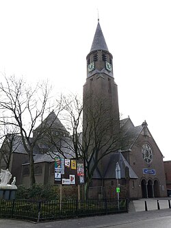
Zundert/NL
Kirche
Kirche
–
–
–
233 910
Foto Staatl.Bildst.Bln.
283
Foto Staatl.Bildst.Bln.
283
Extrahierte Daten
- Urheber:
- –
- Ort:
- Zundert, Kirche
- Titel:
- –
- Material:
- –
- Kategorie:
- –
- Inv.-Nr.:
- 233910, 233283
- Fotograf:
- Staatl.Bildst.Bln.
Kurzinventar · 2
ZI-INVB-KPH-039 · Inv.-Nr. 233211 – 233477
- Herkunft:
- Denkm. dt. K+K
- Zugangsart:
- –
- Datum:
- 1979
ZI-INVB-KPH-039 · Inv.-Nr. 233885 – 233968
- Herkunft:
- Staatl. Bildstelle
- Zugangsart:
- –
- Datum:
- 1979
Geomatch - Verknüpfung mit Normdaten (Orte) · 1
281_01
Gebäude Objekt / Institution
Adresse & Koordinaten · aus Wikidata
Molenstraat 7
4881CP Zundert, Niederlande
51.47162, 4.66385 (address)
© OpenStreetMap-Mitwirkende Größere Karte
Bewertung 95 % · production
The candidate 'Sint-Trudokerk (Zundert)' is the specific church located in Zundert, matching the building name and address, whereas other candidates are either generic, in different cities, or unrelated.
Maschinell aufbereitete Daten
- Stadt (normiert):
- Zundert
- Land:
- Niederlande
- Institution (normiert):
- Kirche
- Einrichtungstyp:
- Bau / in situ
ZI-INVB-PH68-281_01