
Karteikarten (8)
Karteikarte 1 von 8
OCR-Text
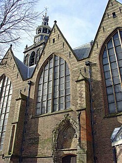
Gouda/NL
St.Janskerk
St.Janskerk
Gouda/NL
St.Janskerk
St.Janskerk
außen: LH u.Kapellen, Ansicht v.
WSW
WSW
–
234 245 Foto Staatl.Bildstelle
N.61
N.61
Extrahierte Daten
- Urheber:
- –
- Ort:
- Gouda/NL, St.Janskerk
- Titel:
- LH u.Kapellen, Ansicht v. WSW
- Material:
- –
- Kategorie:
- –
- Inv.-Nr.:
- 234245
- Fotograf:
- Staatl.Bildstelle N.61
Kurzinventar · 1
ZI-INVB-KPH-039 · Inv.-Nr. 234245 – 234358
- Herkunft:
- Staatl. Bildstelle
- Zugangsart:
- –
- Datum:
- 1979
Geomatch - Verknüpfung mit Normdaten (Orte) · 1
315_01
Gebäude Objekt / Institution
Adresse & Koordinaten · aus Wikidata
Achter de Kerk 1
2801JW Gouda, Niederlande
52.01072, 4.71071 (address)
© OpenStreetMap-Mitwirkende Größere Karte
Bewertung 100 % · backfill
The candidate 'Sint Janskerk (Gouda)' explicitly matches the building name 'St.Janskerk' and the location 'Gouda', confirming it is the correct Wikipedia article for the specified church.
Maschinell aufbereitete Daten
- Kategorie:
- Architektur regelbasiert
- Stadt (normiert):
- Gouda
- Land:
- Niederlande
- Institution (normiert):
- St.Janskerk
- Einrichtungstyp:
- Bau / in situ
Original: Gouda/NL
ZI-INVB-PH68-315_01