
Karteikarten (8)
Karteikarte 1 von 8
OCR-Text
Indersdorf/Kr.Dachau
ehem. Klosterkirche
ehem. Klosterkirche
–
innen-Antoniusaltar
Det.: Stammbaum Christi
M.15.Jh.
Det.: Stammbaum Christi
M.15.Jh.
260 725
(Buchner-Mappe:Gabriel Angler?)
Extrahierte Daten
- Urheber:
- –
- Ort:
- Indersdorf/Kr.Dachau, ehem. Klosterkirche
- Titel:
- innen-Antoniusaltar; Det.: Stammbaum Christi
- Material:
- –
- Kategorie:
- –
- Inv.-Nr.:
- 260725
- Fotograf:
- (Buchner-Mappe:Gabriel Angler?)
Kurzinventar · 1
ZI-INVB-KPH-058 · Inv.-Nr. 260673 – 260757
- Herkunft:
- Nachlaß Büchner
- Zugangsart:
- –
- Datum:
- 1981
- Inhalt:
- Altd. Maler
Datenquelle: manuelle Erfassung Orte · 1
260725
- Titel:
- Pfarrkirche Mariä Himmelfahrt
- Titel (Quelle):
- Markt Indersdorf: Pfarrkirche Mariä Himmelfahrt
- Beschreibung:
- Langhaus, Südseite, 2. Seitenaltar von Osten, Antoniusaltar, Fresko: Stammbaum Christi
- Entstehung von:
- 1445
- Entstehung bis:
- 1455
- Aufnahme von:
- 1920
- Aufnahme bis:
- 1940
- Ort:
- Markt Indersdorf-Indersdorf Kloster
- Ort (Quelle):
- Markt Indersdorf-Indersdorf Kloster
- Gattung:
- Malerei
Geomatch - Verknüpfung mit Normdaten (Orte) · 1
260725
Gebäude Objekt / Institution
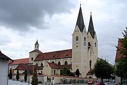
Adresse & Koordinaten · aus Wikidata
Marienplatz 6
85229 Markt Indersdorf, Deutschland
48.35730, 11.38351 (address)
© OpenStreetMap-Mitwirkende Größere Karte
Bewertung 95 % · topd-revised
The candidate article 'Mariä Himmelfahrt (Indersdorf)' explicitly describes the Pfarr- und Klosterkirche Mariä Himmelfahrt in Indersdorf, which matches the building name and address exactly, whereas other candidates refer to different locations or are disambiguated by different cities.
Maschinell aufbereitete Daten
- Stadt (normiert):
- Indersdorf
- Land:
- Deutschland
- Institution (normiert):
- ehemalige Klosterkirche
- Einrichtungstyp:
- Bau / in situ
Original: Indersdorf/Kr.Dachau
Original: ehem. Klosterkirche
Verknüpfte Bilder
ZI-INVB-PH72-024_01