
Karteikarten (8)
Karteikarte 1 von 8
OCR-Text
–
Canterbury
Kloster
Kloster
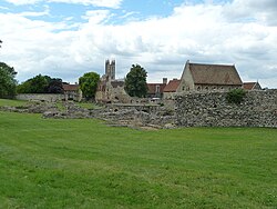
Gang vom Wasserturm
zum nö. Querhaus
zum nö. Querhaus
332 822 Ft.Conw.L./Court.I. A 61/123
–
Extrahierte Daten
- Urheber:
- –
- Ort:
- Canterbury, Kloster
- Titel:
- Gang vom Wasserturm zum nö. Querhaus
- Material:
- –
- Kategorie:
- –
- Inv.-Nr.:
- 332822
- Fotograf:
- Conw.L./Court.I. A 61/123
Kurzinventar · 1
ZI-INVB-KPH-116 · Inv.-Nr. 332726 – 332859
- Herkunft:
- Conw. Lib., Courtl.
- Zugangsart:
- –
- Datum:
- 1987
- Inhalt:
- Canterbury
- Anmerkung:
- Bez. V.
Geomatch - Verknüpfung mit Normdaten (Orte) · 1
390_01
Gebäude Objekt / Institution
Adresse & Koordinaten · nur Region
- Ort:
- Canterbury
- Region:
- England
- Land:
- Vereinigtes Königreich
Bewertung 95 % · production
The building is identified as 'Kloster' in Canterbury, which corresponds to St Augustine's Abbey (Abtei St. Augustinus), the primary historical monastery in that city, as confirmed by the photo descriptions and the article's content.
Maschinell aufbereitete Daten
- Kategorie:
- Architektur KI-Vorhersage
- Stadt (normiert):
- Canterbury
- Land:
- Vereinigtes Königreich
- Institution (normiert):
- Kloster
- Einrichtungstyp:
- Bau / in situ
ZI-INVB-PH82-390_01