
Karteikarten (8)
Karteikarte 1 von 8
OCR-Text
E.18.Jh.
Christerode
Krs. Kassel
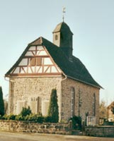
Dorfkirche
Krs. Kassel
Dorfkirche
Ansicht von N W
Arch.
Th 13865
Th 13865
F: Marburg 88795
Extrahierte Daten
- Urheber:
- –
- Ort:
- Christerode, Dorfkirche
- Titel:
- Ansicht von N W
- Material:
- –
- Kategorie:
- Architektur
- Inv.-Nr.:
- Th013865
- Fotograf:
- Marburg 88795
Geomatch - Verknüpfung mit Normdaten (Orte) · 1
421_01
Gebäude Objekt / Institution
Adresse & Koordinaten · nur Region
- Ort:
- Christerode
- Region:
- Hessen
- Land:
- Deutschland
Bewertung 95 % · production
The building name 'Dorfkirche' combined with the location 'Christerode' directly corresponds to the specific article 'Evangelische Kirche Christerode', which is the designated church in that village, whereas other candidates refer to the village itself, a nature reserve, or a list of monuments.
Maschinell aufbereitete Daten
- Kategorie:
- Architektur
- Zeitraum:
- E.18.Jh.
- Stadt (normiert):
- Christerode
- Land:
- Deutschland
- Institution (normiert):
- Dorfkirche
- Einrichtungstyp:
- Bau / in situ
Verknüpfte Bilder
ZI-INVB-THY04-421_01