
Karteikarten (8)
Karteikarte 1 von 8
OCR-Text
1838/4o
N.-Turm
um 12oo
N.-Turm
um 12oo
Guntersblum/ Mainz
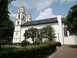
Ev. Pfarrkirche
Ev. Pfarrkirche
Aussenansicht von Süd-Westen
Arch.
Th 1757o
Th 1757o
F: Marburg 67902
Extrahierte Daten
- Urheber:
- –
- Ort:
- Guntersblum, Ev. Pfarrkirche
- Titel:
- N.-Turm, Aussenansicht von Süd-Westen
- Material:
- –
- Kategorie:
- Architektur
- Inv.-Nr.:
- Th017570
- Fotograf:
- Marburg 67902
Geomatch - Verknüpfung mit Normdaten (Orte) · 1
334_01
Gebäude Objekt / Institution
Adresse & Koordinaten · aus Wikidata
Kirchstraße 2
67583 Guntersblum, Deutschland
49.79709, 8.34447 (address)
© OpenStreetMap-Mitwirkende Größere Karte
Bewertung 95 % · production
The candidate article 'St. Viktor (Guntersblum, evangelisch)' explicitly identifies the church in Guntersblum as an evangelical church, matching the building name and location perfectly, whereas other candidates are in different cities or refer to non-church structures.
Maschinell aufbereitete Daten
- Kategorie:
- Architektur
- Zeitraum:
- um 1200
- Stadt (normiert):
- Guntersblum
- Land:
- Deutschland
- Institution (normiert):
- Evangelische Pfarrkirche
- Einrichtungstyp:
- Bau / in situ
Original: Ev. Pfarrkirche
Verknüpfte Bilder
ZI-INVB-THY05-334_01