
Karteikarten (8)
Karteikarte 1 von 8
OCR-Text
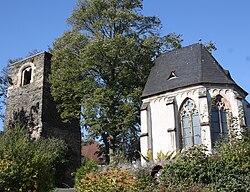
Chor 15.Jh.
Turm 1.H.
12.Jh.
Turm 1.H.
12.Jh.
Welling/ Mayen/Rhld.
Kath.Pfarrkirche,
(Ruine)
Kath.Pfarrkirche,
(Ruine)
Aussenansicht
Arch.
Th 22514
Th 22514
F: Rhein.Bildarch.
46359
46359
Extrahierte Daten
- Urheber:
- –
- Ort:
- Welling, Kath.Pfarrkirche (Ruine)
- Titel:
- Aussenansicht
- Material:
- –
- Kategorie:
- Architektur
- Inv.-Nr.:
- Th022514
- Fotograf:
- Rhein.Bildarch. 46359
Geomatch - Verknüpfung mit Normdaten (Orte) · 1
488_01
Gebäude Objekt / Institution
Adresse & Koordinaten · nur Region
- Ort:
- Welling
- Region:
- Rheinland-Pfalz
- Land:
- Deutschland
Bewertung 95 % · production
The photo title explicitly identifies the building as a 'Ruine' (ruin), which corresponds directly to the 'Alte Kirche' (Old Church) candidate, whereas the other church candidate is a standing parish church built in the 19th century.
Maschinell aufbereitete Daten
- Kategorie:
- Architektur
- Stadt (normiert):
- Welling
- Land:
- Deutschland
- Institution (normiert):
- Kath.Pfarrkirche (Ruine)
- Einrichtungstyp:
- Bau / in situ
Verknüpfte Bilder
ZI-INVB-THY06-488_01