
Karteikarten (8)
Karteikarte 1 von 8
OCR-Text
Entwurf
von Jussow
erster Plan
1790
von Jussow
erster Plan
1790
Kassel
Wilhelmshöhe
Wilhelmshöhe
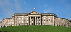
Löwenburg von Westen
Arch.
Th 36856
Th 36856
F: Marburg 73829
Extrahierte Daten
- Urheber:
- Jussow
- Ort:
- Kassel, Wilhelmshöhe
- Titel:
- Löwenburg von Westen
- Material:
- –
- Kategorie:
- Architektur
- Inv.-Nr.:
- Th036856
- Fotograf:
- Marburg 73829
Geomatch - Verknüpfung mit Normdaten (Orte) · 1
294_01
Gebäude Objekt / Institution
Adresse & Koordinaten · nur Region
- Ort:
- Kassel
- Region:
- Hessen
- Land:
- Deutschland
Bewertung 95 % · backfill
The building name 'Wilhelmshöhe' in Kassel primarily refers to the Schloss Wilhelmshöhe, which is the central landmark of the area and matches the specific architectural entity described in candidate [2], whereas other candidates refer to the district, park, or street.
Verknüpfung mit Normdaten (Künstler) · 1
Th036856
Jussow
card_id exact
Karten-Extraktion
abgelehnt · 0.48 zur Prüfung
- Hinweis:
- unzureichende Belege (hohes Risiko)
Maschinell aufbereitete Daten
- Kategorie:
- Architektur
- Stadt (normiert):
- Kassel
- Land:
- Deutschland
- Institution (normiert):
- Schloss Wilhelmshöhe
- Einrichtungstyp:
- Bau / in situ
Original: Wilhelmshöhe
Verknüpfte Bilder
ZI-INVB-THY10-294_01