
Karteikarten (8)
Karteikarte 1 von 8
OCR-Text
13.Jh.
Lohra/ Kassel
Pfarrkirche
Pfarrkirche
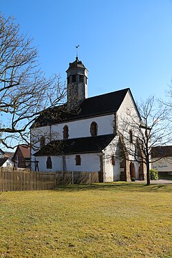
Außenansicht v. N.-O.
Arch.
Th 41814
Th 41814
F: Marburg 1273o
Extrahierte Daten
- Urheber:
- –
- Ort:
- Lohra/ Kassel, Pfarrkirche
- Titel:
- Außenansicht v. N.-O.
- Material:
- –
- Kategorie:
- Architektur
- Inv.-Nr.:
- Th041814
- Fotograf:
- Marburg 12730
Geomatch - Verknüpfung mit Normdaten (Orte) · 1
403_01
Gebäude Objekt / Institution
Adresse & Koordinaten · aus Wikidata
Lindenplatz 6
35102 Lohra, Deutschland
50.73737, 8.63487 (address)
© OpenStreetMap-Mitwirkende Größere Karte
Bewertung 85 % · production
The building is identified as 'Pfarrkirche' in Lohra, and candidate [0] 'Evangelische Kirche Lohra' is the specific church article for the main village of Lohra, which is the most likely referent for the unqualified name in this context.
Maschinell aufbereitete Daten
- Kategorie:
- Architektur
- Zeitraum:
- 13.Jh.
- Stadt (normiert):
- Lohra
- Land:
- Deutschland
- Institution (normiert):
- Pfarrkirche
- Einrichtungstyp:
- Bau / in situ
Original: Lohra/ Kassel
Verknüpfte Bilder
ZI-INVB-THY11-403_01