
Karteikarten (8)
Karteikarte 1 von 8
OCR-Text
1523 u.
2.H.18.Jh.
2.H.18.Jh.
Landl
(B.H.Leoben)
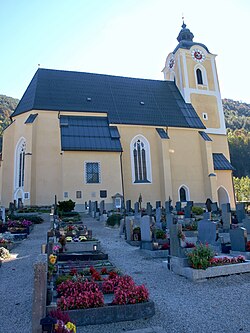
Pfarrkirche St.Bartholomäus
(B.H.Leoben)
Pfarrkirche St.Bartholomäus
Außenansicht von N O
Arch.
Th 73521
Th 73521
F: Woisetschläger
558/ 2
558/ 2
Extrahierte Daten
- Urheber:
- –
- Ort:
- Landl, Pfarrkirche St.Bartholomäus
- Titel:
- Außenansicht von N O
- Material:
- –
- Kategorie:
- Architektur
- Inv.-Nr.:
- Th073521
- Fotograf:
- Woisetschläger 558/ 2
Kurzinventar · 1
ZI-INVB-KTHY-008 · Inv.-Nr. Th073392 – Th073684
- Herkunft:
- Foto Woisetschläger
- Zugangsart:
- –
- Datum:
- 1966
Geomatch - Verknüpfung mit Normdaten (Orte) · 1
361_01
Gebäude Objekt / Institution
Adresse & Koordinaten · aus Wikidata
8931 Landl
47.65195, 14.72785 (street)
© OpenStreetMap-Mitwirkende Größere Karte
Bewertung 95 % · production
The candidate 'Pfarrkirche Landl' corresponds exactly to the requested building 'Pfarrkirche St. Bartholomäus' located in the address 'Landl', whereas other candidates refer to different locations or unrelated topics.
Maschinell aufbereitete Daten
- Kategorie:
- Architektur
- Zeitraum:
- 1523 u. 2.H.18.Jh.
- Stadt (normiert):
- Landl
- Land:
- Österreich
- Institution (normiert):
- Pfarrkirche St.Bartholomäus
- Einrichtungstyp:
- Bau / in situ
ZI-INVB-THY21-361_01