
Karteikarten (8)
Karteikarte 1 von 8
OCR-Text
16.Jh.
Gmünd/Österr.
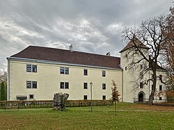
Schloß
Schloß
Außen: Gesamtansicht
Arch.
Th 136578
Th 136578
F: Jeiter R 7537
Extrahierte Daten
- Urheber:
- –
- Ort:
- Gmünd, Schloß
- Titel:
- Außen: Gesamtansicht
- Material:
- –
- Kategorie:
- Architektur
- Inv.-Nr.:
- Th136578
- Fotograf:
- Jeiter R 7537
Kurzinventar · 1
ZI-INVB-KTHY-024 · Inv.-Nr. Th136570 – Th136817
- Herkunft:
- Foto Jeiter
- Zugangsart:
- –
- Datum:
- 1968
Geomatch - Verknüpfung mit Normdaten (Orte) · 1
190_01
Gebäude Objekt / Institution
Adresse & Koordinaten · aus Wikidata
Stadtplatz 1
3945 Gmünd, Österreich
48.77237, 14.98251 (address)
© OpenStreetMap-Mitwirkende Größere Karte
Bewertung 95 % · production
The building name 'Schloß' and address 'Gmünd' directly correspond to the Wikipedia article 'Schloss Gmünd', which is located in Gmünd, Lower Austria, matching the location context provided by the other candidates.
Maschinell aufbereitete Daten
- Kategorie:
- Architektur
- Zeitraum:
- 16.Jh.
- Stadt (normiert):
- Gmünd
- Institution (normiert):
- Schloß
- Einrichtungstyp:
- Bau / in situ
ZI-INVB-THY43-190_01