
Karteikarten (8)
Karteikarte 1 von 8
OCR-Text
A.17.Jh
Spitz/Krems/Österr.-
Pastorenturm"auf dem
Friedhof
Pastorenturm"auf dem
Friedhof
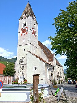
Gesamtansicht
Arch.
Th 13665o
Th 13665o
F: Jeiter R 9147
Extrahierte Daten
- Urheber:
- –
- Ort:
- Spitz/Krems, Pastorenturm "auf dem Friedhof
- Titel:
- Gesamtansicht
- Material:
- –
- Kategorie:
- Architektur / Österreich
- Inv.-Nr.:
- Th136650
- Fotograf:
- Jeiter R 9147
Kurzinventar · 1
ZI-INVB-KTHY-024 · Inv.-Nr. Th136570 – Th136817
- Herkunft:
- Foto Jeiter
- Zugangsart:
- –
- Datum:
- 1968
Geomatch - Verknüpfung mit Normdaten (Orte) · 1
199_01
Gebäude Objekt / Institution
Adresse & Koordinaten · aus Wikidata
Kirchenplatz 11
3620 Spitz, Österreich
48.36601, 15.41406 (address)
© OpenStreetMap-Mitwirkende Größere Karte
Bewertung 85 % · backfill
The building is a specific structure (Pastorenturm) located at the cemetery of the parish church in Spitz; since no specific article exists for the tower, the article for the Pfarrkirche Spitz is the most relevant and geographically correct building candidate among the options.
Maschinell aufbereitete Daten
- Kategorie:
- Architektur
- Zeitraum:
- A.17.Jh
- Stadt (normiert):
- Spitz
- Land:
- Österreich
- Institution (normiert):
- Pastorenturm "auf dem Friedhof"
- Einrichtungstyp:
- Bau / in situ
Original: Spitz/Krems
Original: Pastorenturm "auf dem Friedhof
ZI-INVB-THY43-199_01