
Karteikarten (8)
Karteikarte 1 von 8
OCR-Text
13.u.14.Jh.
Heidingsfeld
Würzbg.
Pfarrk.
Würzbg.
Pfarrk.
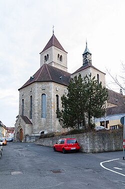
Außenansicht v. SW
Arch.
Th 142623
Th 142623
F:Bayer.Landesa.
Ufr.III
f.Denkmalpfl.
Ufr.III
f.Denkmalpfl.
Extrahierte Daten
- Urheber:
- –
- Ort:
- Heidingsfeld, Würzbg. Pfarrk.
- Titel:
- Außenansicht v. SW
- Material:
- –
- Kategorie:
- Architektur
- Inv.-Nr.:
- Th142623
- Fotograf:
- Bayer.Landesa. Ufr.III f.Denkmalpfl.
Kurzinventar · 1
ZI-INVB-KTHY-030 · Inv.-Nr. Th142623 – Th142674
- Herkunft:
- L.A. München
- Zugangsart:
- –
- Datum:
- 1968
- Anmerkung:
- g
Datenquelle: manuelle Erfassung Orte · 1
Th142623
- Titel:
- Katholische Pfarrkirche Sankt Laurentius
- Titel (Quelle):
- Würzburg: Katholische Pfarrkirche Sankt Laurentius
- Beschreibung:
- Ansicht von Südwesten (1945 zerstört)
- Entstehung von:
- 1100
- Entstehung bis:
- 1408
- Aufnahme von:
- 1906
- Aufnahme bis:
- 1911
- Fotograf:
- Bayerisches Landesamt für Denkmalpflege
- Ort:
- Würzburg-Heidingsfeld
- Ort (Quelle):
- Würzburg-Heidingsfeld
- Gattung:
- Architektur
Geomatch - Verknüpfung mit Normdaten (Orte) · 1
180_01
Gebäude Objekt / Institution
Adresse & Koordinaten · aus Wikidata
Fuchsgasse
97084 Würzburg, Deutschland
49.76268, 9.95119 (street)
© OpenStreetMap-Mitwirkende Größere Karte
Bewertung 95 % · production
The building name 'Würzbg. Pfarrkirche' in Heidingsfeld refers to the local parish church, which is explicitly identified as St. Laurentius in the candidate article [1], matching both the location and building type.
Maschinell aufbereitete Daten
- Kategorie:
- Architektur
- Zeitraum:
- 13.u.14.Jh.
- Stadt (normiert):
- Heidingsfeld
- Land:
- Deutschland
- Institution (normiert):
- Würzbg. Pfarrkirche
- Einrichtungstyp:
- Bau / in situ
Original: Würzbg. Pfarrk.
Verknüpfte Bilder
ZI-INVB-THY45-180_01