
Karteikarten (8)
Karteikarte 1 von 8
OCR-Text
1680-82
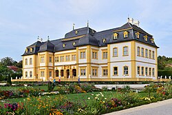
Veitshöchheim
Würzbg.
Schloss
Würzbg.
Schloss
Ansicht v.W.
Arch.
Th 142639
Th 142639
F:Bayer.Landesamt Ufr.III
f.Denkmalpfl. P 179
f.Denkmalpfl. P 179
Extrahierte Daten
- Urheber:
- –
- Ort:
- Veitshöchheim, Würzbg. Schloss
- Titel:
- Ansicht v.W.
- Material:
- –
- Kategorie:
- Architektur
- Inv.-Nr.:
- Th142639
- Fotograf:
- Bayer.Landesamt Ufr.III f.Denkmalpfl. P 179
Kurzinventar · 1
ZI-INVB-KTHY-030 · Inv.-Nr. Th142623 – Th142674
- Herkunft:
- L.A. München
- Zugangsart:
- –
- Datum:
- 1968
- Anmerkung:
- g
Datenquelle: manuelle Erfassung Orte · 1
Th142639
- Titel:
- Lustgarten
- Titel (Quelle):
- Veitshöchheim: Lustgarten
- Beschreibung:
- Löwentreppe, westliche Treppe zum Schlossparterre
- Entstehung von:
- 1702
- Entstehung bis:
- 1703
- Aufnahme von:
- 1906
- Aufnahme bis:
- 1911
- Fotograf:
- Bayerisches Landesamt für Denkmalpflege
- Ort:
- Veitshöchheim
- Ort (Quelle):
- Veitshöchheim
- Gattung:
- Architektur
Geomatch - Verknüpfung mit Normdaten (Orte) · 1
182_01
Gebäude Objekt / Institution
Adresse & Koordinaten · aus Wikidata
Echterstraße 10
97209 Veitshöchheim, Deutschland
49.83170, 9.87465 (address)
© OpenStreetMap-Mitwirkende Größere Karte
Bewertung 95 % · production
The building name 'Würzbg. Schloss' combined with the address 'Veitshöchheim' clearly refers to the Schloss Veitshöchheim, which is the primary candidate and accurately described in the first building candidate.
Maschinell aufbereitete Daten
- Kategorie:
- Architektur
- Zeitraum:
- 1680-82
- Stadt (normiert):
- Veitshöchheim
- Land:
- Deutschland
- Institution (normiert):
- Würzbg. Schloss
- Einrichtungstyp:
- Bau / in situ
Verknüpfte Bilder
ZI-INVB-THY45-182_01