
Karteikarten (8)
Karteikarte 1 von 8
OCR-Text
1548
Krems
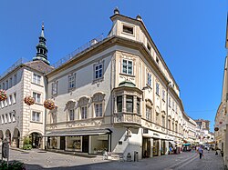
Rathaus
Obere Landstr. 4
Rathaus
Obere Landstr. 4
Erker
Arch.
Th 150027
Th 150027
F: Bundesdenkmal-
amt Wien
N 14355
amt Wien
N 14355
Extrahierte Daten
- Urheber:
- –
- Ort:
- Krems, Rathaus Obere Landstr. 4
- Titel:
- Erker
- Material:
- –
- Kategorie:
- Architektur
- Inv.-Nr.:
- Th150027
- Fotograf:
- Bundesdenkmal-amt Wien N 14355
Kurzinventar · 2
ZI-INVB-KTHY-034 · Inv.-Nr. Th150011 – Th150036
- Herkunft:
- Foto Mus. Bundesdenkmalamt Wien
- Zugangsart:
- –
- Datum:
- 1968
ZI-INVB-KTHY-045 · Inv.-Nr. Th147858 – Th175120
- Herkunft:
- Foto Zwicker
- Zugangsart:
- –
- Datum:
- 1969
Geomatch - Verknüpfung mit Normdaten (Orte) · 1
134_01
Gebäude Objekt / Institution
Adresse & Koordinaten · aus Wikidata
Obere Landstraße 4
3500 Krems an der Donau, Österreich
48.41127, 15.60000 (address)
© OpenStreetMap-Mitwirkende Größere Karte
Bewertung 95 % · production
The article 'Rathaus Krems' explicitly describes the town hall of Krems an der Donau, which matches the building name and location, despite the slight discrepancy in the specific street address provided in the query versus the article's description (Pfarrplatz vs Obere Landstr.), as this is the only specific building candidate for the city.
Maschinell aufbereitete Daten
- Kategorie:
- Architektur
- Stadt (normiert):
- Krems
- Land:
- Österreich
- Institution (normiert):
- Rathaus Obere Landstr. 4
- Einrichtungstyp:
- Bau / in situ
ZI-INVB-THY47-134_01