
Karteikarten (8)
Karteikarte 1 von 8
OCR-Text
–
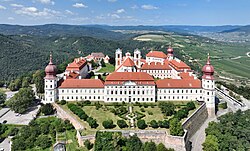
Göttweig
Stift
Stift
Stiftskirche, Fassade
Arch.
Th 161181
Th 161181
F:Bildarch.d.
Österr.Nat.Bibl.
148 407
Österr.Nat.Bibl.
148 407
Extrahierte Daten
- Urheber:
- –
- Ort:
- Göttweig, Stift
- Titel:
- Stiftskirche, Fassade
- Material:
- –
- Kategorie:
- Architektur
- Inv.-Nr.:
- Th161181
- Fotograf:
- Bildarch.d. Österr.Nat.Bibl. 148 407
Kurzinventar · 2
ZI-INVB-KTHY-041 · Inv.-Nr. Th160899 – Th161373
- Herkunft:
- Foto Oe. N. B.
- Zugangsart:
- –
- Datum:
- 1969
ZI-INVB-KTHY-045 · Inv.-Nr. Th147858 – Th175120
- Herkunft:
- Foto Zwicker
- Zugangsart:
- –
- Datum:
- 1969
Geomatch - Verknüpfung mit Normdaten (Orte) · 1
024_01
Gebäude Objekt / Institution
Adresse & Koordinaten · aus Wikidata
Stift Göttweig 1
3511 Furth bei Göttweig, Österreich
48.36650, 15.61236 (address)
© OpenStreetMap-Mitwirkende Größere Karte
Bewertung 100 % · production
The building candidate 'Stift Göttweig' exactly matches the address 'Göttweig' and describes the Benedictine monastery located there, whereas other candidates refer to different entities or unrelated topics.
Maschinell aufbereitete Daten
- Kategorie:
- Architektur
- Stadt (normiert):
- Göttweig
- Land:
- Österreich
- Institution (normiert):
- Stift
- Einrichtungstyp:
- Bau / in situ
ZI-INVB-THY50-024_01