
Karteikarten (8)
Karteikarte 1 von 8
OCR-Text
–
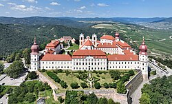
Göttweig
Stiftskirche
Stiftskirche
Mittelschiff nach W.
Arch.
Th 161228
Th 161228
F:Bildarch.d.
Österr.Nat.Bibl. 246
4
Österr.Nat.Bibl. 246
4
Extrahierte Daten
- Urheber:
- –
- Ort:
- Göttweig, Stiftskirche
- Titel:
- Mittelschiff nach W.
- Material:
- –
- Kategorie:
- Architektur
- Inv.-Nr.:
- Th161228
- Fotograf:
- Bildarch.d. Österr.Nat.Bibl. 246 4
Kurzinventar · 2
ZI-INVB-KTHY-041 · Inv.-Nr. Th160899 – Th161373
- Herkunft:
- Foto Oe. N. B.
- Zugangsart:
- –
- Datum:
- 1969
ZI-INVB-KTHY-045 · Inv.-Nr. Th147858 – Th175120
- Herkunft:
- Foto Zwicker
- Zugangsart:
- –
- Datum:
- 1969
Geomatch - Verknüpfung mit Normdaten (Orte) · 1
030_01
Gebäude Objekt / Institution
Adresse & Koordinaten · aus Wikidata
Stift Göttweig 1
3511 Furth bei Göttweig, Österreich
48.36650, 15.61236 (address)
© OpenStreetMap-Mitwirkende Größere Karte
Bewertung 95 % · production
The address 'Göttweig' corresponds to the location of the Stift Göttweig, and the building name 'Stiftskirche' refers to the collegiate church within this monastery, which is the subject of the candidate article.
Maschinell aufbereitete Daten
- Kategorie:
- Architektur
- Stadt (normiert):
- Göttweig
- Land:
- Österreich
- Institution (normiert):
- Stiftskirche
- Einrichtungstyp:
- Bau / in situ
ZI-INVB-THY50-030_01