
Karteikarten (8)
Karteikarte 1 von 8
OCR-Text
1171-79
Chur
Kathedrale
Kathedrale
Kapitellzone v.NO., südwestl.
Chorquadratpfl.
Chorquadratpfl.
Arch.
Th 165997
Th 165997
Foto Marburg
4511
4511
Extrahierte Daten
- Urheber:
- –
- Ort:
- Chur, Kathedrale
- Titel:
- Kapitellzone v.NO., südwestl. Chorquadratpfl.
- Material:
- –
- Kategorie:
- Architektur
- Inv.-Nr.:
- Th165997
- Fotograf:
- Marburg 4511
Kurzinventar · 2
ZI-INVB-KTHY-043 · Inv.-Nr. Th165981 – Th166506
- Herkunft:
- Foto Marburg
- Zugangsart:
- –
- Datum:
- 1969
ZI-INVB-KTHY-045 · Inv.-Nr. Th147858 – Th175120
- Herkunft:
- Foto Zwicker
- Zugangsart:
- –
- Datum:
- 1969
Geomatch - Verknüpfung mit Normdaten (Orte) · 1
254_01
Gebäude Objekt / Institution
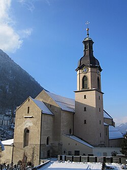
Adresse & Koordinaten · aus Wikidata
Hof 18
7000 Chur, Schweiz
46.84765, 9.53544 (address)
© OpenStreetMap-Mitwirkende Größere Karte
Bewertung 95 % · production
The candidate article 'Kathedrale St. Mariä Himmelfahrt (Chur)' explicitly identifies the cathedral in Chur, matching the building name and location perfectly, whereas other candidates refer to different buildings or are enclosing entities.
Maschinell aufbereitete Daten
- Kategorie:
- Architektur
- Zeitraum:
- 1171-79
- Stadt (normiert):
- Chur
- Land:
- Schweiz
- Institution (normiert):
- Kathedrale
- Einrichtungstyp:
- Bau / in situ
ZI-INVB-THY51-254_01