
Karteikarten (8)
Karteikarte 1 von 8
OCR-Text
–
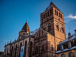
Straßburg
St. Thomas
St. Thomas
Kircheninneres
Arch.
Th 172057
Th 172057
F: Ehem.Staatl.
Bildst.Berlin
91/338/22
Bildst.Berlin
91/338/22
Extrahierte Daten
- Urheber:
- –
- Ort:
- Straßburg, St. Thomas
- Titel:
- Kircheninneres
- Material:
- –
- Kategorie:
- Architektur
- Inv.-Nr.:
- Th172057
- Fotograf:
- Ehem.Staatl. Bildst.Berlin 91/338/22
Kurzinventar · 2
ZI-INVB-KTHY-044 · Inv.-Nr. Th171943 – Th172416
- Herkunft:
- Ehem. Staatl. Bildst. Berlin
- Zugangsart:
- –
- Datum:
- 1969
ZI-INVB-KTHY-045 · Inv.-Nr. Th147858 – Th175120
- Herkunft:
- Foto Zwicker
- Zugangsart:
- –
- Datum:
- 1969
Geomatch - Verknüpfung mit Normdaten (Orte) · 1
008_01
Gebäude Objekt / Institution
Adresse & Koordinaten · aus Wikidata
Thomasgasse 4
67000 Straßburg, Frankreich
48.57968, 7.74520 (address)
© OpenStreetMap-Mitwirkende Größere Karte
Bewertung 95 % · backfill
The building 'St. Thomas' in Straßburg corresponds to the Thomaskirche (Église Saint-Thomas), which is the main Lutheran church in the city and matches the name and location perfectly.
Maschinell aufbereitete Daten
- Kategorie:
- Architektur
- Stadt (normiert):
- Straßburg
- Land:
- Frankreich
- Institution (normiert):
- St. Thomas
- Einrichtungstyp:
- Bau / in situ
ZI-INVB-THY53-008_01