
Karteikarten (8)
Karteikarte 1 von 8
OCR-Text
–
Ehrenburg
Lagebild
Lagebild
vom Talgrund aus
Arch.
Th 174 029
Th 174 029
F: Ehem.Staatl.
Bildst.Berlin
K 5992. 3
Bildst.Berlin
K 5992. 3
Extrahierte Daten
- Urheber:
- –
- Ort:
- –
- Titel:
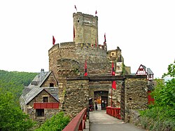
- Ehrenburg Lagebild vom Talgrund aus
- Material:
- –
- Kategorie:
- Architektur
- Inv.-Nr.:
- Th174029
- Fotograf:
- Ehem.Staatl. Bildst.Berlin K 5992. 3
Kurzinventar · 2
ZI-INVB-KTHY-045 · Inv.-Nr. Th147858 – Th175120
- Herkunft:
- Foto Zwicker
- Zugangsart:
- –
- Datum:
- 1969
ZI-INVB-KTHY-045 · Inv.-Nr. Th174021 – Th174742
- Herkunft:
- Ehem. Staatl. Bildst. Berlin
- Zugangsart:
- –
- Datum:
- 1969
Datenquelle: manuelle Erfassung Orte · 1
Th174029
- Titel:
- Ehrenburg
- Titel (Quelle):
- Brodenbach: Ehrenburg
- Beschreibung:
- Ansicht von Norden, Lagebild mit Umgebung, Blick vom Talgrund aus (seit 1689 Ruine)
- Entstehung von:
- 1160
- Aufnahme von:
- 1900
- Aufnahme bis:
- 1940
- Fotograf:
- Staatliche Bildstelle Berlin
- Ort:
- Brodenbach-Ehrenburg
- Ort (Quelle):
- Brodenbach-Ehrenburg
- Gattung:
- Architektur
Geomatch - Verknüpfung mit Normdaten (Orte) · 1
Th174029
Gebäude Objekt / Institution
Adresse & Koordinaten · nur Region
- Ort:
- Brodenbach-Ehrenburg
- Region:
- Rheinland-Pfalz
- Land:
- Deutschland
Bewertung 100 % · topd-revised
The building candidate 'Ehrenburg (Brodenbach)' explicitly matches the building name and the specific location (Brodenbach) provided in the address, and the photo descriptions of the ruin align with the article's content.
Maschinell aufbereitete Daten
- Kategorie:
- Architektur
Verknüpfte Bilder
ZI-INVB-THY53-262_01