
Karteikarten (8)
Karteikarte 1 von 8
OCR-Text
Koblenz
Kastorkirche
Kastorkirche
–
Kirchenschiff, Mittel-
schiff
schiff
Arch.
Th 174 621
Th 174 621
F: Ehem.Staatl.
Bildst.Berlin
589/D875/14
Bildst.Berlin
589/D875/14
Extrahierte Daten
- Urheber:
- –
- Ort:
- Koblenz, Kastorkirche
- Titel:
- Kirchenschiff, Mittelschiff
- Material:
- –
- Kategorie:
- Architektur
- Inv.-Nr.:
- Th174621
- Fotograf:
- Ehem.Staatl. Bildst.Berlin 589/D875/14
Kurzinventar · 2
ZI-INVB-KTHY-045 · Inv.-Nr. Th147858 – Th175120
- Herkunft:
- Foto Zwicker
- Zugangsart:
- –
- Datum:
- 1969
ZI-INVB-KTHY-045 · Inv.-Nr. Th174021 – Th174742
- Herkunft:
- Ehem. Staatl. Bildst. Berlin
- Zugangsart:
- –
- Datum:
- 1969
Geomatch - Verknüpfung mit Normdaten (Orte) · 1
337_01
Gebäude Objekt / Institution
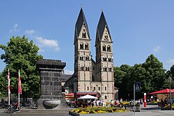
Adresse & Koordinaten · aus Wikidata
Kastorhof 8
56068 Koblenz, Deutschland
50.36166, 7.60395 (address)
© OpenStreetMap-Mitwirkende Größere Karte
Bewertung 100 % · production
The article 'St. Kastor (Koblenz)' explicitly states that the Basilica St. Kastor is also known as 'Kastorkirche' and is located in Koblenz, matching the building name and address perfectly.
Maschinell aufbereitete Daten
- Kategorie:
- Architektur
- Stadt (normiert):
- Koblenz
- Land:
- Deutschland
- Institution (normiert):
- Kastorkirche
- Einrichtungstyp:
- Bau / in situ
ZI-INVB-THY53-337_01