
Karteikarten (8)
Karteikarte 1 von 8
OCR-Text
–
Koblenz
KastorKirche
KastorKirche
Mittelschiff-Nordwand
westl.Joche v.S.
westl.Joche v.S.
Arch.
Th 174666
Th 174666
F:Ehem.Staati.
Bildst.Berlin
589/C 6017.6
Bildst.Berlin
589/C 6017.6
Extrahierte Daten
- Urheber:
- –
- Ort:
- Koblenz, KastorKirche
- Titel:
- Mittelschiff-Nordwand westl.Joche v.S.
- Material:
- –
- Kategorie:
- Architektur
- Inv.-Nr.:
- Th174666
- Fotograf:
- Ehem.Staati. Bildst.Berlin 589/C 6017.6
Kurzinventar · 2
ZI-INVB-KTHY-045 · Inv.-Nr. Th147858 – Th175120
- Herkunft:
- Foto Zwicker
- Zugangsart:
- –
- Datum:
- 1969
ZI-INVB-KTHY-045 · Inv.-Nr. Th174021 – Th174742
- Herkunft:
- Ehem. Staatl. Bildst. Berlin
- Zugangsart:
- –
- Datum:
- 1969
Datenquelle: manuelle Erfassung Orte · 1
Th174666
- Titel:
- Ehemalige Stiftskirche Sankt Kastor
- Titel (Quelle):
- Koblenz: Ehemalige Stiftskirche Sankt Kastor
- Beschreibung:
- Langhaus, Mittelschiff, Nordwand, westliche Joche
- Entstehung von:
- 1147
- Entstehung bis:
- 1208
- Aufnahme von:
- 1930
- Aufnahme bis:
- 1940
- Fotograf:
- Staatliche Bildstelle Berlin
- Ort:
- Koblenz
- Ort (Quelle):
- Koblenz
- Gattung:
- Architektur
Geomatch - Verknüpfung mit Normdaten (Orte) · 1
343_01
Gebäude Objekt / Institution
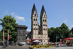
Adresse & Koordinaten · aus Wikidata
Kastorhof 8
56068 Koblenz, Deutschland
50.36166, 7.60395 (address)
© OpenStreetMap-Mitwirkende Größere Karte
Bewertung 100 % · production
The building name 'KastorKirche' directly corresponds to the article 'St. Kastor (Koblenz)', which is explicitly identified as 'auch Kastorkirche genannt' (also called Kastor Church) and is located in Koblenz.
Maschinell aufbereitete Daten
- Kategorie:
- Architektur
- Stadt (normiert):
- Koblenz
- Land:
- Deutschland
- Institution (normiert):
- KastorKirche
- Einrichtungstyp:
- Bau / in situ
Verknüpfte Bilder
ZI-INVB-THY53-343_01