
Karteikarten (8)
Karteikarte 1 von 8
OCR-Text
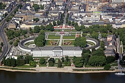
Koblenz
Schloß
Schloß
–
30. Juli 2001
Als Dublette ausgeschieden
Gesamansicht im
Platzbilde v.West
Als Dublette ausgeschieden
Gesamansicht im
Platzbilde v.West
Arch.
Th 175269
Th 175269
F:Ehem.Staalt.
Bildst.Berlin
591/C 6044/1
Bildst.Berlin
591/C 6044/1
Extrahierte Daten
- Urheber:
- –
- Ort:
- Koblenz, Schloß
- Titel:
- Gesamansicht im Platzbilde v.West
- Material:
- –
- Kategorie:
- Architektur
- Inv.-Nr.:
- Th175269
- Fotograf:
- Ehem.Staalt. Bildst.Berlin 591/C 6044/1
Kurzinventar · 1
ZI-INVB-KTHY-045 · Inv.-Nr. Th175172 – Th175873
- Herkunft:
- Ehem. Staatl. Bildst. Berlin
- Zugangsart:
- –
- Datum:
- 1969
Geomatch - Verknüpfung mit Normdaten (Orte) · 1
424_01
Gebäude Objekt / Institution
Adresse & Koordinaten · aus Wikidata
Neustadt
56068 Koblenz, Deutschland
50.35639, 7.59936 (street)
© OpenStreetMap-Mitwirkende Größere Karte
Bewertung 95 % · production
The Kurfürstliches Schloss (Koblenz) is the primary and most prominent castle located directly in Koblenz, matching the address and building type perfectly, whereas other candidates are in different cities or are not castles.
Maschinell aufbereitete Daten
- Kategorie:
- Architektur
- Stadt (normiert):
- Koblenz
- Land:
- Deutschland
- Institution (normiert):
- Schloß
- Einrichtungstyp:
- Bau / in situ
ZI-INVB-THY53-424_01