
Karteikarten (8)
Karteikarte 1 von 8
OCR-Text
nordöstl.Teil
mit Nr.9-13
mit Nr.9-13
Koblenz
Am Plan
Am Plan
–
Arch.
Th 175727
Th 175727
F:Ehem.Staatl.
Bildst.Berlin
C 6033.2
Bildst.Berlin
C 6033.2
Extrahierte Daten
- Urheber:
- –
- Ort:
- Koblenz, Am Plan
- Titel:
- –
- Material:
- –
- Kategorie:
- Architektur
- Inv.-Nr.:
- Th175727
- Fotograf:
- Ehem.Staatl. Bildst.Berlin C 6033.2
Kurzinventar · 1
ZI-INVB-KTHY-045 · Inv.-Nr. Th175172 – Th175873
- Herkunft:
- Ehem. Staatl. Bildst. Berlin
- Zugangsart:
- –
- Datum:
- 1969
Datenquelle: manuelle Erfassung Orte · 1
Th175727
- Titel:
- Am Plan
- Titel (Quelle):
- Koblenz: Am Plan
- Beschreibung:
- Nordseite mit den Türmen der Liebfrauenkirche
- Aufnahme von:
- 1920
- Aufnahme bis:
- 1940
- Fotograf:
- Staatliche Bildstelle Berlin
- Ort:
- Koblenz
- Ort (Quelle):
- Koblenz
- Gattung:
- Architektur
Geomatch - Verknüpfung mit Normdaten (Orte) · 1
Th175727
Gebäude Objekt / Institution
WM Holger Weinandt · CC BY-SA 3.0 de
Am Plan other
Adresse & Koordinaten · nur Region
- Ort:
- Koblenz
- Region:
- Rheinland-Pfalz
- Land:
- Deutschland
Bewertung 95 % · topd-revised
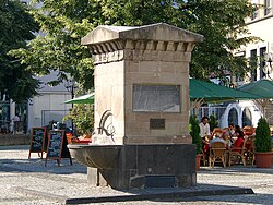
The photo evidence explicitly mentions the 'Liebfrauenkirche' (Liebfrauen Church) in the context of 'Am Plan', and the candidate article 'Brunnen Am Plan' is the only building-related entity located at this specific address in Koblenz, serving as the primary landmark for the square.
Maschinell aufbereitete Daten
- Kategorie:
- Architektur
- Stadt (normiert):
- Koblenz
- Land:
- Deutschland
- Institution (normiert):
- Am Plan
Verknüpfte Bilder
ZI-INVB-THY53-481_01