
Karteikarten (8)
Karteikarte 1 von 8
OCR-Text
30. Juli 2001
Marburg
Schloß
Schloß
Als Dublette ausgeschieden
Innerer Schloßhof
Längsbild n.O.
(alter Zustand)
Innerer Schloßhof
Längsbild n.O.
(alter Zustand)
Arch.
Th 175799
Th 175799
F:Ehem.Staati.
Bildst.Berlin
C 5460.21
Bildst.Berlin
C 5460.21
Extrahierte Daten
- Urheber:
- –
- Ort:
- Marburg, Schloß
- Titel:
- Innerer Schloßhof Längsbild n.O. (alter Zustand)
- Material:
- –
- Kategorie:
- Architektur
- Inv.-Nr.:
- Th175799
- Fotograf:
- Ehem.Staati. Bildst.Berlin C 5460.21
Kurzinventar · 1
ZI-INVB-KTHY-045 · Inv.-Nr. Th175172 – Th175873
- Herkunft:
- Ehem. Staatl. Bildst. Berlin
- Zugangsart:
- –
- Datum:
- 1969
Geomatch - Verknüpfung mit Normdaten (Orte) · 1
490_01
Gebäude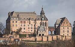
Adresse & Koordinaten · aus Wikidata
Schloß 1
35037 Marburg, Deutschland
50.81008, 8.76731 (address)
© OpenStreetMap-Mitwirkende Größere Karte
Bewertung 100 % · production
The building candidate 'Marburger Schloss' explicitly matches the requested building name 'Schloß' and the location 'Marburg', and the description confirms it is a prominent building in the city.
Maschinell aufbereitete Daten
- Kategorie:
- Architektur
- Stadt (normiert):
- Marburg
- Land:
- Deutschland
- Institution (normiert):
- Schloß
- Einrichtungstyp:
- Bau / in situ
ZI-INVB-THY53-490_01