
Karteikarten (8)
Karteikarte 1 von 8
OCR-Text
–
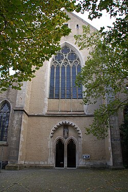
Regensburg
Dominikanerkirche, Kreuzgang,
Ostflügel nach Süd
Ostflügel nach Süd
Th
181998
181998
F: Ehem.Staatl.
Bildst.Berlin
530/C 4919/9
Bildst.Berlin
530/C 4919/9
Extrahierte Daten
- Urheber:
- –
- Ort:
- Regensburg, Dominikanerkirche, Kreuzgang, Ostflügel nach Süd
- Titel:
- –
- Material:
- –
- Kategorie:
- –
- Inv.-Nr.:
- Th181998
- Fotograf:
- Ehem.Staatl. Bildst.Berlin 530/C 4919/9
Kurzinventar · 1
ZI-INVB-KTHY-046 · Inv.-Nr. Th181386 – Th182136
- Herkunft:
- Ehem. Staatl. Bildst. Berlin
- Zugangsart:
- –
- Datum:
- 1970
Datenquelle: manuelle Erfassung Orte · 1
Th181998
- Titel:
- Katholische Kirche Sankt Blasius (ehemalige Dominikanerklosterkirche)
- Titel (Quelle):
- Regensburg: Katholische Kirche Sankt Blasius (ehemalige Dominikanerklosterkirche)
- Beschreibung:
- Innenansicht des Ostflügel im Kreuzgang, Blick nach Süden
- Entstehung von:
- 1229
- Entstehung bis:
- 1229
- Aufnahme von:
- 1900
- Aufnahme bis:
- 1930
- Fotograf:
- Staatliche Bildstelle Berlin
- Ort:
- Regensburg
- Ort (Quelle):
- Regensburg
- Gattung:
- Architektur
Geomatch - Verknüpfung mit Normdaten (Orte) · 1
264_01
Gebäude Objekt / Institution
Adresse & Koordinaten · aus Wikidata
Am Ölberg 4
93047 Regensburg, Deutschland
49.01770, 12.09092 (address)
© OpenStreetMap-Mitwirkende Größere Karte
Bewertung 95 % · production
The building name 'Dominikanerkirche' matches the candidate 'Dominikanerkirche St. Blasius (Regensburg)' in the correct city, whereas the other building candidate refers to the Dom (Cathedral) and the enclosing candidate is only the city level.
Maschinell aufbereitete Daten
- Stadt (normiert):
- Regensburg
- Land:
- Deutschland
- Institution (normiert):
- Dominikanerkirche, Kreuzgang, Ostflügel nach Süd
- Einrichtungstyp:
- Bau / in situ
Verknüpfte Bilder
ZI-INVB-THY55-264_01