
Karteikarten (8)
Karteikarte 1 von 8
OCR-Text
–
Regensburg
St.Emmeran
St.Emmeran
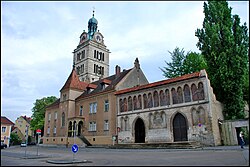
äußere Klosterpforte
etwa axial
etwa axial
Arch.
Th 186540
Th 186540
F:Ehem.Staatl.
Bildst.Berlin
529/C.4910.2
Bildst.Berlin
529/C.4910.2
Extrahierte Daten
- Urheber:
- –
- Ort:
- Regensburg, St.Emmeran
- Titel:
- äußere Klosterpforte, etwa axial
- Material:
- –
- Kategorie:
- Architektur
- Inv.-Nr.:
- Th186540
- Fotograf:
- Ehem.Staatl. Bildst.Berlin 529/C.4910.2
Kurzinventar · 1
ZI-INVB-KTHY-047 · Inv.-Nr. Th186099 – Th186866
- Herkunft:
- Ehem. Staatl. Bildstelle Berlin
- Zugangsart:
- –
- Datum:
- 1970
Datenquelle: manuelle Erfassung Orte · 1
Th186540
- Titel:
- Katholische Pfarrkirche Sankt-Emmeran (ehemalige Benediktinerabteikirche)
- Titel (Quelle):
- Regensburg: Katholische Pfarrkirche Sankt-Emmeran (ehemalige Benediktinerabteikirche)
- Beschreibung:
- Detailansicht: Äußere Klosterpforte von Norden
- Entstehung von:
- 1250
- Entstehung bis:
- 1250
- Aufnahme von:
- 1915
- Aufnahme bis:
- 1935
- Fotograf:
- Staatliche Bildstelle Berlin
- Ort:
- Regensburg
- Ort (Quelle):
- Regensburg
- Gattung:
- Architektur
Geomatch - Verknüpfung mit Normdaten (Orte) · 1
325_01
Gebäude Objekt / Institution
Adresse & Koordinaten · aus Wikidata
Emmeramsplatz 4
93047 Regensburg, Deutschland
49.01538, 12.09290 (address)
© OpenStreetMap-Mitwirkende Größere Karte
Bewertung 95 % · backfill
The building 'St. Emmeran' refers to the historic monastery complex in Regensburg, which is accurately described by the Wikipedia article 'Kloster Sankt Emmeram'; candidate [0] refers specifically to the church building, but the monastery article is the more comprehensive match for the entity name and location.
Maschinell aufbereitete Daten
- Kategorie:
- Architektur
- Stadt (normiert):
- Regensburg
- Land:
- Deutschland
- Institution (normiert):
- St.Emmeran
- Einrichtungstyp:
- Bau / in situ
Verknüpfte Bilder
ZI-INVB-THY56-325_01