
Karteikarten (8)
Karteikarte 1 von 8
OCR-Text
um 1400
Gratwein/Steierm.
Pfarrkirche
Hl. Rupert
Pfarrkirche
Hl. Rupert
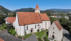
Außenansicht v.S-Seite
Arch.
Th 192264
Th 192264
Foto Woisetschläger
1144/1
1144/1
Extrahierte Daten
- Urheber:
- –
- Ort:
- Gratwein/Steierm., Pfarrkirche Hl. Rupert
- Titel:
- Außenansicht v.S-Seite
- Material:
- –
- Kategorie:
- Architektur
- Inv.-Nr.:
- Th192264
- Fotograf:
- Woisetschläger 1144/1
Kurzinventar · 1
ZI-INVB-KTHY-048 · Inv.-Nr. Th192161 – Th192360
- Herkunft:
- Foto Woisetschläger
- Zugangsart:
- –
- Datum:
- 1970
Geomatch - Verknüpfung mit Normdaten (Orte) · 1
036_01
Gebäude Objekt / Institution
Adresse & Koordinaten · aus Wikidata
Kirchengasse 22
8112 Gratwein-Straßengel, Österreich
47.13089, 15.31888 (address)
© OpenStreetMap-Mitwirkende Größere Karte
Bewertung 95 % · production
The candidate 'Pfarrkirche St. Rupert (Gratwein)' explicitly matches the building name and location, whereas the other candidates refer to the municipality, the merged municipality, a castle, or a different village.
Maschinell aufbereitete Daten
- Kategorie:
- Architektur
- Zeitraum:
- um 1400
- Stadt (normiert):
- Gratwein
- Land:
- Österreich
- Institution (normiert):
- Pfarrkirche Hl. Rupert
- Einrichtungstyp:
- Bau / in situ
Original: Gratwein/Steierm.
ZI-INVB-THY58-036_01