
Karteikarten (8)
Karteikarte 1 von 8
OCR-Text
–
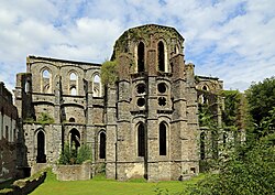
Villers-la-Ville
Klosterruine
Klosterruine
Blick a. d. südl. Westturm
a. d. Nordwand v. MS
a. d. Nordwand v. MS
Th2 25 247
Foto Marburg
2oo 855
2oo 855
Extrahierte Daten
- Urheber:
- –
- Ort:
- Villers-la-Ville, Klosterruine
- Titel:
- Blick a. d. südl. Westturm a. d. Nordwand v. MS
- Material:
- –
- Kategorie:
- –
- Inv.-Nr.:
- Th225247
- Fotograf:
- Marburg 200 855
Kurzinventar · 1
ZI-INVB-KTHY-072 · Inv.-Nr. Th224951 – Th225398
- Herkunft:
- Foto Marburg
- Zugangsart:
- –
- Datum:
- 1972
Geomatch - Verknüpfung mit Normdaten (Orte) · 1
344_01
Gebäude Objekt / Institution
Adresse & Koordinaten · nur Region
- Ort:
- Villers-la-Ville
- Region:
- Bourgogne-Franche-Comté
- Land:
- Frankreich
Bewertung 95 % · production
The building name 'Klosterruine' combined with the address 'Villers-la-Ville' directly corresponds to the Wikipedia article for the former Cistercian monastery in the Belgian municipality of Villers-la-Ville, which is a well-known ruin.
Maschinell aufbereitete Daten
- Kategorie:
- Architektur KI-Vorhersage
- Stadt (normiert):
- Villers-la-Ville
- Land:
- Belgien
- Institution (normiert):
- Klosterruine
- Einrichtungstyp:
- Bau / in situ
ZI-INVB-THY63-344_01